
1828 Finley Map of Louisiana 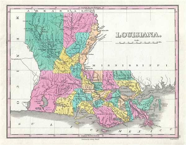 WE SELL ONLY ORIGINAL ANTIQUE MAPS - NOT REPRODUCTIONS Title: Louisiana. Description: This is an 1828 Anthony Finley map of Louisiana. The map depicts the state from Mexico to Mississippi and from Arkansas to the Gulf of Mexico in Finleys classic minimalist style. Rivers, roads, canals, and some topographical features are illustrated. Numerous cities, towns, and townships are labeled throughout the map, including New Orleans and Baton Rouge. Counties are labeled and differentiated by color, allowing for easy recognition. This map also features an early county configuration in Louisiana. Various American Indian villages noted throughout the state but particularly in the western part. Southwest Pass, in the Mississippi River Delta, is mislabeled Northwest Pass. Natchitoches, Louisiana, and its sister city Narogdoches, Texas are both identified. This map was engraved by Young and Delleker for the 1828 edition of Anthony Finleys General Atlas. Size: Printed area measures 9 inches high by 11.25 inches wide. Condition: Very good. Blank on verso. Shipping: Shipping rates are not negotiable. Items are shipped within three business days of receiving payment. We are happy to consolidate shipping where possible. The following shipping options are available: 1. FedEx Overnight (45 USD). USA Only. Signature Required. Customs: International buyers are responsible for paying duty and taxes on delivery. DHL or FedEx will contact the buyer by telephone to arrange tax payment if it is levied. Duty varies by country and we cannot predict the amount you will be charged. Some countries are duty free, others are not. Typically, a customs duty and/or VAT tax will be assessed on all parcels to continental Europe. Sometimes duty or tax is due in China, but is seems very random. Hong Kong, Singapore, Korea, and Taiwan have never assessed duty on a map we shipped. Maps shipped to the UK should be duty free as educational materials, but from time to time duty of 5% is assessed incorrectly by the UK customs agents. Insurance: All shipments are insured privately against loss and damage. All of our shipments require a signature for insurance purposes. If you have any questions please feel free to email us through eBay. Other Services Conservation Framing: Geographicus recommends basic conservation framing services for any antique paper. We do not offer this service. |

" class="zoomMainImage swiper-slide">
1828 Finley Map of Louisiana WE SELL ONLY ORIGINAL ANTIQUE MAPS - NOT REPRODUCTIONS Title: Louisiana. Description: This is an 1828 Anthony Finley map of Louisiana. The map depicts the state from Mexico to Mississippi and from Arkansas to the Gulf of Mexico in Finleys classic minimalist style. Rivers, roads, canals, and some topographical features are illustrated. Numerous cities, towns, and townships are labeled throughout the map, including New Orleans and Baton Rouge. Counties are labeled and differentiated by color, allowing for easy recognition. This map also features an early county configuration in Louisiana. Various American Indian villages noted throughout the state but particularly in the western part. Southwest Pass, in the Mississippi River Delta, is mislabeled Northwest Pass. Natchitoches, Louisiana, and its sister city Narogdoches, Texas are both identified. This map was engraved by Young and Delleker for the 1828 edition of Anthony Finleys General Atlas. Size: Printed area measures 9 inches high by 11.25 inches wide. Condition: Very good. Blank on verso. Shipping: Shipping rates are not negotiable. Items are shipped within three business days of receiving payment. We are happy to consolidate shipping where possible. The following shipping options are available: 1. FedEx Overnight (45 USD). USA Only. Signature Required. Customs: International buyers are responsible for paying duty and taxes on delivery. DHL or FedEx will contact the buyer by telephone to arrange tax payment if it is levied. Duty varies by country and we cannot predict the amount you will be charged. Some countries are duty free, others are not. Typically, a customs duty and/or VAT tax will be assessed on all parcels to continental Europe. Sometimes duty or tax is due in China, but is seems very random. Hong Kong, Singapore, Korea, and Taiwan have never assessed duty on a map we shipped. Maps shipped to the UK should be duty free as educational materials, but from time to time duty of 5% is assessed incorrectly by the UK customs agents. Insurance: All shipments are insured privately against loss and damage. All of our shipments require a signature for insurance purposes. If you have any questions please feel free to email us through eBay. Other Services Conservation Framing: Geographicus recommends basic conservation framing services for any antique paper. We do not offer this service. |
" alt="1828 Finley achats Map of Louisiana" width="527" height="527" />
1828 Finley achats Map of Louisiana
1828 Finley achats Map of Louisiana, 1828 Finley Map of Louisiana soldes
€342.53
SKU: 484917
Colour
"
1828 Finley Map of Louisiana
WE SELL ONLY ORIGINAL ANTIQUE MAPS - NOT REPRODUCTIONS
Title: Louisiana.
Description: This is an 1828 Anthony Finley map of Louisiana. The map depicts the state from Mexico to Mississippi and from Arkansas to the Gulf of Mexico in Finleys classic minimalist style. Rivers, roads, canals, and some topographical features are illustrated. Numerous cities, towns, and townships are labeled throughout the map, including New Orleans and Baton Rouge. Counties are labeled and differentiated by color, allowing for easy recognition. This map also features an early county configuration in Louisiana. Various American Indian villages noted throughout the state but particularly in the western part. Southwest Pass, in the Mississippi River Delta, is mislabeled Northwest Pass. Natchitoches, Louisiana, and its sister city Narogdoches, Texas are both identified.
This map was engraved by Young and Delleker for the 1828 edition of Anthony Finleys General Atlas.
Size: Printed area measures 9 inches high by 11.25 inches wide.
Condition: Very good. Blank on verso.
Shipping: Shipping rates are not negotiable. Items are shipped within three business days of receiving payment. We are happy to consolidate shipping where possible. The following shipping options are available:1. FedEx Overnight (45 USD). USA Only. Signature Required.
2. FedEx Ground or Home Delivery (15 USD). USA Only. 1 - 10 days. If your address is a P.O. Box and cannot ship FedEx we will ship USPS Priority and, while we ship promptly, recent postal personnel cutbacks mean that delivery may take time. Signature Required.
3. FedEx International or DHL International EXPRESS (45 USD).
4. We can use your FedEx Account.
Customs: International buyers are responsible for paying duty and taxes on delivery. DHL or FedEx will contact the buyer by telephone to arrange tax payment if it is levied. Duty varies by country and we cannot predict the amount you will be charged. Some countries are duty free, others are not. Typically, a customs duty and/or VAT tax will be assessed on all parcels to continental Europe. Sometimes duty or tax is due in China, but is seems very random. Hong Kong, Singapore, Korea, and Taiwan have never assessed duty on a map we shipped. Maps shipped to the UK should be duty free as educational materials, but from time to time duty of 5% is assessed incorrectly by the UK customs agents.
Insurance: All shipments are insured privately against loss and damage. All of our shipments require a signature for insurance purposes.
If you have any questions please feel free to email us through eBay.
Other ServicesConservation Framing: Geographicus recommends basic conservation framing services for any antique paper. We do not offer this service.
Antique Map Restoration: Geographicus can repair and restore your antique map. Services include deacidification cleaning flattening and backing.
BEWARE anyone attempting to contact you, from a different eBay account, claiming to represent Geographicus Antique Maps. My eBay handle is GeographicusMaps. If you are contacted by email by someone offering you my items, please call me directly to be certain you are not dealing with a con artist." alt="1828 Finley achats Map of Louisiana" width="52" height="52" >
Personalised:: ( x )Personalisation:EditRemove PersonalisationAvailable From:
Buy now.
Pay later.
Earn rewards
Representative APR: 29.9% (variable)
Credit subject to status. Terms apply.
Missed payments may affect your credit score
FrasersPlus
Available Products
SIMILAR ITEMS
- 1828 Finley Map of Louisiana
- Robe Designer Soie Mélange avec Ceinture SANDRO Paris
- A.P.C. Pxadmf61048 Iak Dark Navy Demi Lune Beau design Facile à utiliser et dura
- Armure demi-corps chevalier médiéval acier chasseur de dame - costume armure femme - Larp Co
- JB3S097 BOÎTE DE VITESSES / 33116 POUR RENAULT MEGANE I SCENIC JA01996-> 1.6
- Taille homme adidas Adizero Evo SL Lucid Lemon Core noir JR3416
- Turbocompresseur, suralimentation EVORON EVTC0095 pour MICRA III (K12) 1.5 2003
- Sandales et sandales Alexander McQueen Platform Buckle noires EU-36 PRIX DE VENTE CONSEILLÉ 1495 $
- Jante PEUGEOT 408 9844304380
- 1 pièce NEUF module lumberg 0970 PSL111 FedEx ou FedEx#L/
Back to top